Land Allocation and Valuation Models Phase 2
A comparison of ecosystem service models using real life case studies
Ecosystem service modelling tools allow for the assessment of the current or potential for improvement in the state of ecosystem services. They often quantify hydrological, climate regulatory or biodiversity related processes in order to assess their health, benefit to people, or their related risks and opportunities.
The aim of our project is to compare different ecosystem service modelling tools and apply these tools across multiple scales (e.g. site to region to national level). Based on the range of complexity and ease-of-use represented across the ecosystem service tools assessed, we propose 6 tools/approaches for in-depth review and road-testing.
Researcher Jessica Finan introduces the project in this short video
Model 1: InVEST
Advantages: Free, Open source, detailed online manuals available, quick running time, scenario modelling functions available, InVEST ‘stack exchange style’ modelling forum available for users to obtain advice, and extensive InVEST modelling literature available.
Limitations: data requirements are high
Model 2: LUCI
Advantages: Simple to use, can be weighted by case study ecosystem service priorities, trade-off ‘traffic light’ maps identifying areas where one ecosystem service may require more attention than others, low data input, can select a variety of ecosystem service combinations to model, and easily interpreted outputs.
Limitations: In running the model, expert opinion may be necessary to check and adjust default settings such as water quality thresholds.
Model 3: Natural Capital Planning Tool (NCPT)
Advantages: Free, open source, 25 year projections of development impacts on natural capital (NC) or ecosystem service, easy to use, highly transparent and flexible, potential for use as an ecosystem service offsetting tool, demand for a particular ecosystem service can be used to weight it by priority, and it can inform ecosystem service improvement needs for the site.
Limitations: Somewhat high data requirements, may require expert interpretation, cannot replace existing development mitigations such as environmental impact assessments (EIAs) or ecologists on site.
Model 4: Land choices guide
Advantages: Simple to understand, highly interactive, low data input required, can be applied across multiple scales, previously run with pilot projects already.
Limitations: Highly dependent on local and professional expertise to make land use decisions, requires site visitation.
Model 5: Natural Environment Valuation online tool
Advantages: Free, open source, easily interpreted, scenario modelling function, low data input requirement, maps available locating areas for ecosystem service improvement.
Limitations: May require expert interpretation, and modelling is not flexible outside of the set model parameters, i.e. edits to weighting systems or code.
Model 6: Eco-metric
Advantages: Easy to understand output, inclusive of a wide range of ecosystem services, transparent and flexible
Limitations: May require expertise to run, not intuitive to use, high data requirement
Different scales were tested at three case study sites
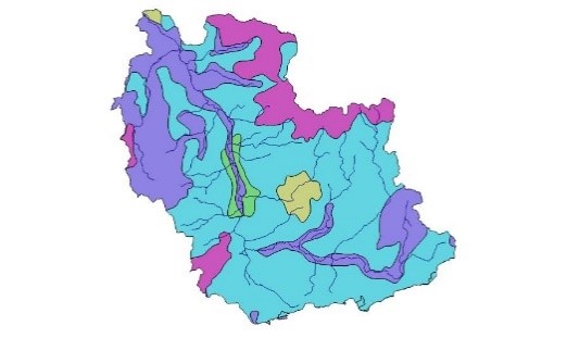
Environment Agency, Cranleigh Waters
Aims: Benefit local wildlife, people, businesses, tourists, anglers, improve water quality and mitigate flooding. There is a wish to ID sites within the catchment with potential for multiple ecosystem service benefits.
Site characteristics: Large area of river catchment, with a high diversity of habitat types. An area of natural beauty (AONB) with 31 river water bodies, all but one of which are failing water framework directive targets (WFD). Phosphates, macrophytes and fish are causes of these failures.
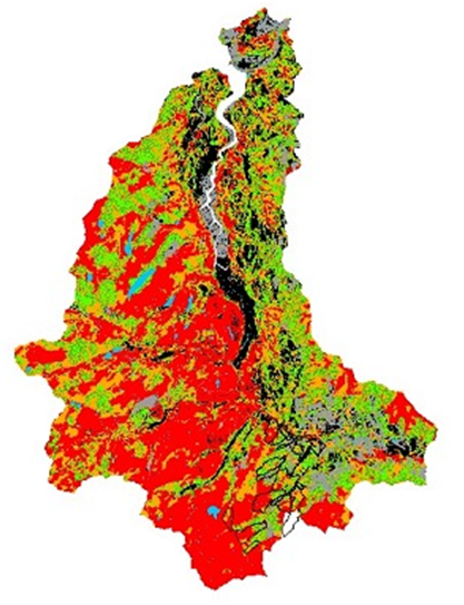
Conwy Catchment, CEH
Aims: Habitat creation, flood risk mitigation, carbon sequestration
Site characteristics: 580 km2 area, of which 380km2 is above the tidal limit, large areas of strongly or steeply sloping land. 52%Agricultural Land Class5, and 28%ALC 4,with a significant area classified as other (11%). 25% improved grass, 20% acid grass, 10% rough grass and 11% heather grass.
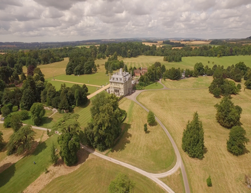
National Trust, Bishop Court farm
Site characteristics: 850 acres of mixed farm land on the west side of the Kingston Lacy Estate. There are 125 acres of water meadow alongside the River Stour which are permanent pasture running with a plain sward. The Stour Valley Way long distance footpath, passes through the water meadows. The remainder of the farm is under conventional arable cropping (including cereals and oilseed rape). The farm is mostly grade 3 agricultural land (some grade 2 and 4), with chalk, loam and clay soils.
Numerous differences were identified between model results in the direction and strength of land use change impacts on ecosystem service provision. Some changes appear to be due to the scale and type of change that occurs. These discrepancies may result from variation in model sensitivity and the modelling processes themselves. Most models agreed on the directional change of ecosystem service provision under land use change scenarios; however, there was significantly more variation in the strength of impacts seen between model outputs. Under smaller scale case studies, we see stronger impacts on ecosystem service provision for complex and simple models. As the size of the case study area scales up, we see more variation in the strength of land use change effects. This may result from a combination of the variation in model performance at difference scales, and for different ecosystem services.